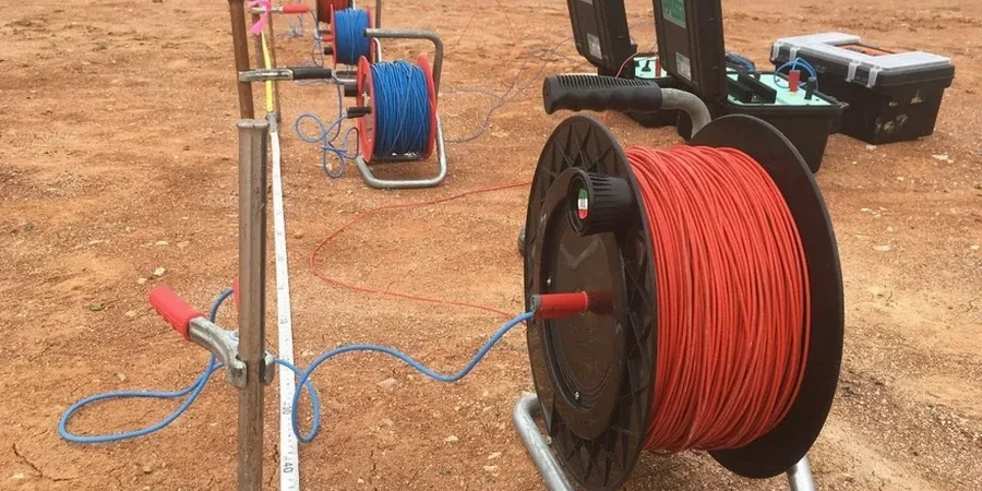
The Wenner array spreads out across the grass—four stainless steel electrodes hammered into the ground at precise spacings, cables running back to a resistivity meter housed in a yellow Pelicase. That is the setup we use for Vertical Electrical Sounding in Plymouth, and it is the same solid Terrameter LS2 unit that has served us on dozens of sites from the limestone headlands of the Hoe to the alluvial flats of the Plym valley. The principle is straightforward: we inject a known current through the outer electrodes, measure the potential drop between the inner pair, and calculate apparent resistivity. As we increase the electrode separation, the current penetrates deeper, building a layered picture of what lies beneath—very useful in a city where the geology can switch from Devonian slate to estuarine mud within the length of a single housing plot. For schemes where ground investigation needs to go beyond the borehole, we often pair the resistivity profile with seismic refraction to cross-check bedrock velocity against the resistivity boundary.
A VES survey tells you where the wet clay stops and the limestone starts without putting a single hole in the ground.
Methodology applied in Plymouth
Typical technical challenges in Plymouth
BS 5930:2015+A1:2020 and BS EN 1997-2 (Eurocode 7, ground investigation) frame every resistivity campaign we run in Plymouth, and they are particularly relevant here because of the city's history of tidal reclamation and karstic limestone. Millbay and much of the city centre sits on infilled tidal creeks where buried organic layers—former saltmarsh deposits—can go undetected by standard window sampling yet produce a clear low-resistivity signature on a VES traverse. The bigger risk in Plymouth, though, is solution features in the Devonian limestone: cavities and widened joints that can collapse under foundation load. A resistivity low in a limestone setting is a red flag that demands follow-up, usually with targeted drilling. Skipping the geophysical stage means accepting a level of subsurface uncertainty that no ground investigation report should carry when the consequence of a missed void could be a foundation failure.
Our services
We run VES surveys as a standalone service or bundled with other ground investigation techniques depending on what the Plymouth site demands. Each scope below is tailored to BS 5930 and the specific geological unit encountered.
2D Electrical Resistivity Tomography (ERT)
Multi-electrode profiles that build a continuous cross-section of subsurface resistivity. Ideal for mapping lateral changes—such as the edge of a buried channel or the boundary between limestone and slate—across a site transect in Plymouth.
1D Vertical Electrical Sounding (VES)
Point-depth investigation using expanding Wenner or Schlumberger arrays. We use this for foundation-level profiling where a single layered model is sufficient, particularly on compact urban plots in areas like Stoke or Mutley.
Combined geophysical and intrusive package
Resistivity data calibrated against dynamic probing or rotary boreholes. This is the approach we recommend for Plymouth sites with suspected karst features, where the geophysics guides the drilling and the drilling validates the geophysics.
Quick answers
How much does a VES resistivity survey cost for a typical Plymouth building plot?
For a single-house plot or small extension footprint we usually work within £530 to £920, depending on the number of soundings, electrode spread length, and whether you need a standalone interpretive report or integration with existing borehole data.
Can VES detect voids in the Plymouth limestone?
It can detect the conditions that suggest voids—specifically, air-filled cavities produce very high resistivity anomalies, while clay-filled solution features show a relative low. VES alone cannot confirm a void; it tells us where to drill. In Plymouth's Devonian limestone we treat any sharp lateral resistivity contrast as a target for intrusive follow-up.
How long does a VES survey take on site?
A set of three to five soundings on an open plot typically takes half a day, including electrode layout, measurement, and demobilisation. Constrained urban sites with hardstanding or buried services take longer because we have to adapt electrode positions. Data processing and reporting are usually completed within three to five working days.
Is resistivity testing affected by the tide in Plymouth?
Yes, especially on sites close to the Tamar or Plym estuaries. Tidal fluctuations change the pore-water salinity in near-surface sediments, which alters the measured resistivity. We always note tide state and, for intertidal or waterfront sites, schedule soundings at a consistent stage of the tidal cycle so that repeat measurements are comparable.