Compliance with BS 1377-9 and the UK National Annex to Eurocode 7 (BS EN 1997-2:2007) is the only acceptable benchmark when verifying earthworks compaction in Plymouth. The city's geological profile, dominated by Devonian slate and siltstone of the Saltash Formation with pockets of head deposits along the Plym and Tamar estuaries, creates highly variable platform conditions. A standard Proctor curve developed for one area rarely translates directly to another site half a mile away. Our field density test using the sand cone method provides the direct physical measurement that nuclear gauge correlations cannot always resolve in these heterogeneous residual soils, which is why we deploy it as the primary method for acceptance testing on road subbase, pipeline trench backfill, and foundation pad preparation throughout the Plymouth City Council jurisdiction. We also integrate findings with laboratory grain size analysis to validate field moisture-density relationships against the material's actual particle distribution when discrepancies arise between site results and the design specification.
In Plymouth's slate-derived soils, a 1% shift in moisture content can drop field density by 3%, making the sand cone's direct measurement the most defensible method for earthworks sign-off.
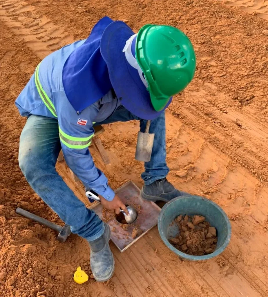
Methodology applied in Plymouth
Typical technical challenges in Plymouth
One practical observation we frequently make on sites across the Derriford and Estover expansion zones is that imported granular fill is often placed over weathered slate without a proper transition layer, leading to a density reading that passes on the fill surface but masks a soft interface six inches down. The sand cone method only evaluates the top 150–200 mm of the lift, so if the underlying material is not proof-rolled or assessed via a deeper test pit excavation, the compaction certificate can misrepresent the true layer stiffness. The risk compounds in the winter months when Plymouth's annual rainfall exceeds 1,000 mm; saturated slate fines can pump upward through the granular layer under traffic loading, causing rapid loss of compaction and subsequent pavement deformation. A technically rigorous programme combining sand cone density with occasional deep inspection and laboratory Atterberg limits testing provides the cross-verification necessary to avoid these latent defects before the structural section is placed.
Our services
Our Plymouth-based density testing programme covers the full sequence from laboratory reference compaction through to field verification and compliance reporting, adapted to the local Devonian geology and the earthworks specifications typical of South West England infrastructure projects.
Sand Cone Field Density Measurement
Direct in-place density and unit weight determination on compacted earthworks, subbase, and trench backfill using the sand replacement method calibrated to BS 1377-9, with immediate moisture content reporting and relative compaction calculation against the laboratory Proctor reference.
Laboratory Compaction Reference (Proctor)
Development of the moisture-density relationship (BS 1377-4) using the specific site material, providing the target maximum dry density and optimum moisture content that the field sand cone results are evaluated against for earthworks acceptance.
Nuclear Gauge Correlation and Verification
Site-specific calibration of nuclear density gauges against sand cone reference measurements, establishing the offset curves required when clients or contractors prefer the speed of indirect methods for ongoing process control during bulk earthworks.
Quick answers
What is the typical cost for a sand cone field density test in Plymouth?
For sites within the Plymouth travel area, a single sand cone density test with full reporting typically falls in the range of £80 to £120, depending on the number of tests per day and the complexity of the site access. A day rate for multiple points distributed across a larger earthworks operation is generally more cost-effective, and we can provide a site-specific quotation once the testing frequency and lift schedule are defined.
How does the sand cone method compare to a nuclear density gauge?
The sand cone method is a direct volumetric measurement: you excavate the soil, weigh it, and fill the hole with a calibrated sand of known density to determine the in-place volume. A nuclear gauge, by contrast, infers density from the attenuation of gamma radiation, which can be influenced by the soil's chemical composition (ironstone, slag, high mica content) common in some Plymouth fills. The sand cone is therefore considered the referee method and is required for nuclear gauge calibration and for final acceptance where specification disputes arise.
What is the minimum number of tests required per day on a Plymouth earthworks site?
The frequency is governed by the project specification, but drawing from Series 600 of the Manual of Contract Documents for Highway Works, a common benchmark is one test per 250 to 500 square metres per compacted lift for general fill, with increased frequency near structures and in trench backfill. The exact rate should be agreed with the supervising engineer and is influenced by the material variability and the consequence of under-compaction, particularly in the silty slate fills encountered around Plymouth.
Can the sand cone test be performed on coarse granular fill?
BS 1377-9 accommodates material with a maximum particle size up to 37.5 mm using the 200 mm base plate, though the presence of larger cobbles common in some Plymouth demolition-derived fills may require an oversized replacement test or a shift to a different methodology. We assess the particle size distribution beforehand, often via a grain size analysis, to confirm the sand cone method is applicable and to select the appropriate plate diameter and excavation depth.